New paper on OzTrack published in Animal Biotelemetry

Want to read more about the OzTrack/ZoaTrack project? Check out our recent publication in Animal Biotelemetry, where we describe the underlying ‘nuts and bolts’ of the system, and discuss applications of the software to species management and conservation.

Animal Biotelemetry

This paper is also a useful resource for users looking to cite OzTrack/ZoaTrack when reporting on how their animal tracking data was processed and analysed in reports and scientific publications.

You can also read an interview relating to this at the BioMed central blog network, where I discuss how this online tool benefits the science community, can increase community involvement and why an open access approach to software and data is the future for conservation science.

Posted in Uncategorized | Comments Off on New paper on OzTrack published in Animal Biotelemetry

Racing whale sharks around the world

ECOOCEAN are using ZoaTrack.org as an outreach platform to engage school children with science and nature.  They have already satellite tagged 12 whale sharks, with each device and animal linked to primary or secondary school. The viusal platofrm of ZoaTrack and the analysis tools on offer enable anyway to log on view and analyse the whale shark movement information. The project is a joint initiative between the WA Department of Education, and is a  great example of how ZoaTrack can be used to promote research, education and conservation.

View the Whale Shark tracks here OR go to ZoaTrack.org and search the data repository.

Posted in Uncategorized | Comments Off on Racing whale sharks around the world

ZoaTrack is the new OzTrack

zoatrack_final   is the new  OzTracklogo

A lot has happened in the last year.

The OzTrack platform has been rehomed and is now supported and governed by the Atlas of Living Australia. We have a new larger Scientific Steering Committee, and the look and feel of the old platform has been significantly upgraded.

The name of the platform and domain has also changed to zoaTrack.org (Zoa – Latin for animals). We believe this name better reflects our growing international community of users.

Log on. Try uploading some of your own data, or play with some analysis tools on existing data within our repository.

Posted in Uncategorized | Comments Off on ZoaTrack is the new OzTrack

Why should you share your hard-won animal telemetry data?

This is a question I am often asked by those tagging and tracking animals.

I believe the main reason to share animal telemetry is to ensure data longevity and make it possible to assess how animal movement may be changing through time.

Moreover, every animal that is captured and tagged is impacted upon by the procedure. We are therefore, ethically obliged to ensure the findings from our studies are maximised -even if this occurs long after we are finished with the data.

There are also personal benefits to you as a user by sharing your data. It will advertise publications arising from the research, and others may think of a new way of synthesis for these data, opening up new collaborations, publication and funding opportunities.

A recent study published in Science of the Total Environment, estimated that out of the thousands of animals whose movements have been tracked across Australasia, the findings from less than 50 % have been published. Significantly less (8 %) are discoverable via online resources. The aim of the zoaTrack platform is to turn this statistic around, so that these data can be discovered and compared into the future.

In using the zoaTrack.org platform access to your data-collection can be embargoed for a limited time, but go on, make it open-access and allow others to view these amazing data-sets.

Posted in Uncategorized | Comments Off on Why should you share your hard-won animal telemetry data?

OzTrack.org to feature at AWMS and ECOTAS13!

The OzTrack team are pleased to announce that OzTrack.org will feature at the upcoming Australasian Wildlife Management Society (AWMS) and ECOTAS13 conferences later this month, across the Tasman Sea in New Zealand.

Conferences attendees include researchers, academics, students, consultants,  land managers, government workers and manufacturers – all with a core interest in ecology and/or wildlife management.

During the conference talks, our Scientific Data Analyst Dr Ross Dwyer will be demonstrating the core functions of the OzTrack software. In particular, how these new tools can help ecologists and wildlife managers in data management and interpretation, and in increasing the exposure of their own research, conservation programs and management initiatives.

Please contact Ross if you’d like to arrange a meeting, or alternatively just say ‘hello!’

Posted in Uncategorized | Tagged , | Comments Off on OzTrack.org to feature at AWMS and ECOTAS13!

Animals tracked with tiny tags summon their own drones – tech – 09 October 2013 – New Scientist

Miniature GPS tags create a network between themselves and deliver data payloads through that network to drones.

Animals tracked with tiny tags summon their own drones – tech – 09 October 2013 – New Scientist.

Posted in Uncategorized | Tagged | 1 Comment

This Bird Can Stay in Flight for Six Months Straight | Surprising Science

This Bird Can Stay in Flight for Six Months Straight | Surprising Science.

Posted in Uncategorized | Tagged | Comments Off on This Bird Can Stay in Flight for Six Months Straight | Surprising Science

OzTrack featured in AWMS newsletter

AWMS logo

An article describing the OzTrack project has been published in the recent newsletter of the Australasian Wildlife Management Society (AWMS). The article ‘OzTrack: new online software for the analysis of animal tracking data’ describes the functionality of the site and provides example tracks and home range estimates for two southern cassowaries fitted with GPS loggers.

kernel as google earth2

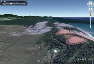
Home range kernels (95% and 50% KUDs) of two cassowaries, generated in OzTrack and featured in the July AWMS newsletter

This is the first release of the OzTrack project to the Australasian animal tracking community. Our hope is that wildlife managers and students will be able to use OzTrack’s tools to assist with their own research projects to help achieve positive conservation outcomes and/or improve species management.

Cassowary fitted with GPS-based telemetry device. Photo credits: Hamish Campbell

Posted in event, news, OzTrack, update | Tagged , , , , , , , , | Comments Off on OzTrack featured in AWMS newsletter

Marine layers and new tools added to the OzTrack project

Image 1

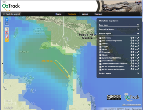
The track of an Olive Ridley turtle off the west coast of Cape York, Queensland, Australia. The track is overlayed on the CARS2009 phosphate dataset with 40% opacity. The measuring tool shows clearly that the animal travels over 300 km from the Queensland coast.

After discussion with Australian and New Zealand researchers tracking animals in the marine environment, we are pleased to announce the addition of the CSIRO Atlas of Regional Seas (CARS 2009) climatological dataset to OzTrack.org.

Now OzTrack users can overlay their tracking data on a suite of georeferenced layers describing water properties across the world’s oceans. This includes sea surface temperature, salinity, sea surface height, oxygen, nitrate, silicate and phosphate. The data covers the full global oceans on a 0.5 degree grid and each cell holds the average/interpolated profile data for that locality.

With these recent additions, OzTrack now holds 21 environmental layers obtained from online geospatial repositories. We offer a ‘point-and-click’ querying tool to extract data from the animal’s track (i.e. animal ID, date, time and coordinates of the location fix) and the environmental characteristics of that locality (e.g. sea surface temperature, salinity). We have also increased the size of the map window, and added a measuring tool and opacity slider to the OzTrack toolkit.

It is our hope these recent additions will help our users tracking animals in both terrestrial and marine systems to better understand the environment in which their tagged animals inhabit.

Check out the new environmental layers at http://oztrack.org


Posted in Uncategorized | Tagged , , , , , | Comments Off on Marine layers and new tools added to the OzTrack project

14 new environmental layers now available within OzTrack!

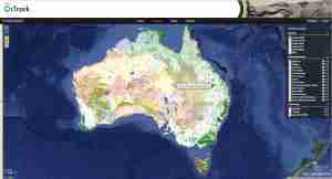
The OzTrack team are proud to announce that 14 new environmental layers have been incorporated into the OzTrack website. These layers may be queried from within OzTrack to provide spatial and temporal information on habitat preference and reserve design.

Along with Bathymetry and Elevation data obtained from General Bathymetric Chart of the Oceans (GEBCO), a map of Australian Natural Resource Management (NRM) Regional Boundaries is provided as well as a map of fire frequency using data from the NOAA Satellite Information System.

Fire and NRM

Your animal tracks may now be overlayed on maps of terrestrial and marine protected areas from CAPAD 2010 and Australia’s network of Commonwealth Marine Reserves. This may allow wildlife managers to investigate whether the current design of these areas is sufficient to protect their study species.

CAPD Commonwealth

We have incorporated land-use data from Australia’s Dynamic Land Cover dataset which reflect the structural character of vegetation. These range from cultivated and managed land covers (crops and pastures) to natural land covers such as closed forest and open grasslands.

Landuse

With the National Vegetation Information System (NVIS) Groups and Subgroup layers, we provide the latest summary information (November 2012) on Australia’s present native vegetation. The input vegetation data were provided from over 100 individual projects representing the majority of Australia’s regional vegetation mapping over the last 50 years. Data were obtained from the Environmental Resources Information Network (ERIN), Department of Sustainability Environment Water Population and Communities.

NVIS

Finally the IBRA (Interim Biogeographic Regionalisation for Australia) regions and subregion layers, and the IMCRA (Integrated Marine and Coastal Regionalisation of Australia) provincial and mesoscale layers may also be visualised. These represent spatial units that contain broad patterns in biodiversity in the terrestrial and marine environment.

It is our hope to add more environmental layers to http://oztrack.org in the coming months.

Posted in Uncategorized | Tagged , , , , , | Comments Off on 14 new environmental layers now available within OzTrack!